Contact OPTRON to find out more about our complete range of Hydrographic Survey solutions!
The most important part of mapping a water body may be the part you cannot see.
Conditions and changes below the water surface provide information about aspects of the site that surface observations cannot capture.
A bathymetric survey adds this underwater dimension to the wider site picture, giving surveyors and project teams a more complete understanding of the project environment.

What Is a Bathymetric Survey?
Bathymetry measures water depth and maps submerged terrain. Surveyors collect measurements at accurately positioned points to represent the shape and contours of the underwater surface.
A bathymetric survey forms part of the wider field of hydrographic survey work, turning those measurements into underwater profiles or terrain models that provide a spatial record of the surveyed area.
Where Are Bathymetric Surveys Used?
Bathymetric surveying is used across different water environments where underwater areas are relevant to the project. The survey focus depends on the information required.
Dams, Reservoirs and Mine Water Bodies
Dam and reservoir surveys provide measurable information about the submerged terrain. Teams may use the data to establish depths, map bed levels or compare underwater conditions between surveys.
Mine water bodies can present additional challenges around access or safe deployment. Bathymetric mapping enables teams to investigate submerged areas using a survey approach that suits on-site conditions.
Rivers, Canals and Harbours
Flowing waterways and engineered channels have different mapping requirements. River surveys can establish channel depths and bed profiles, while canal mapping provides similar information across managed waterways.
Harbour surveys provide depth and underwater terrain information for monitoring and planning in these environments.
Bathymetric data can contribute to project requirements such as:
-
Establishing baseline underwater conditions
-
Tracking sediment or capacity changes
-
Identifying areas that require further investigation
-
Providing spatial data for ongoing water-body management
-
Informing engineering and design decisions


What Technology Is Used for Bathymetric Surveying?
Bathymetric surveying relies on specialised equipment to connect water-depth measurements with precise locations. The survey environment influences how teams collect that information.
Echo Sounders and Single Beam Sonar
An echo sounder transmits an acoustic signal toward the bottom and measures the time it takes to return. The system uses that measurement to determine the distance between the transducer and the underwater surface.
Single beam sonar, including solutions such as OPTRON’s HydroLite Plus, collects depth measurements directly beneath the survey platform as it follows survey lines across the water. Combining these readings with GNSS positioning systems gives each measured depth a known location.
Unmanned Surface Vehicles
An unmanned surface vehicle carries hydrographic survey instruments without requiring an onboard crew. Surveyors can operate these platforms remotely or program autonomous routes to collect data throughout the survey area.
USVs provide a practical option for confined or difficult-to-access water bodies and environments where sending personnel onto the water may introduce unnecessary risk.
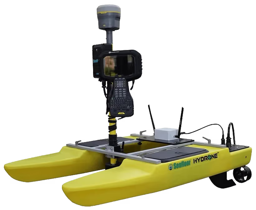
Survey requirements determine the platform and sensor configuration. OPTRON’s Seafloor Systems range includes compact platforms such as the HyDrone, the multibeam-focused Trident and the EchoBoat 160 for different hydrographic survey requirements.
Bathymetric surveying combines different technologies to collect and position depth data:
| Technology / Equipment | Survey Function | Capability | Survey Consideration |
|---|---|---|---|
| Echo Sounder | Measures water depth | Uses acoustic signals to establish depth | Match the system to the required depth and application |
| Single Beam Sonar | Collects depth measurements along survey lines | Builds positioned depth profiles | Plan survey-line spacing around required coverage |
| GNSS Positioning | Establishes measurement location | Links depth readings to known positions | Match positioning accuracy to project requirements |
| USV / Autonomous Surface Vehicle | Carries survey sensors | Enables remote or autonomous collection | Consider access and deployment conditions |
What Does Bathymetric Survey Data Tell You?
Bathymetric data turns underwater conditions into information that surveyors and project teams can assess. Depending on the survey purpose, the results provide measurable data for engineering decisions and ongoing monitoring.
Survey data provides information about:
-
Water depths across the surveyed area
-
Underwater contours and terrain
-
Bed levels and changes in elevation
-
Sediment accumulation where the survey scope supports assessment
-
Submerged features within the scope of the survey
Repeat surveys let teams compare the underwater surface at different points in time. Consistent datasets make it possible to identify measurable changes and assess how conditions have shifted.
Find A Hydrographic Survey Solution for Bathymetric Surveying
Your objectives provide the starting point for selecting suitable technology. OPTRON can guide you through the available options, making it easier to choose based on what you need to achieve.
Talk to OPTRON about your survey requirements and discover the Seafloor Survey Solutions.